
pinnacle peak
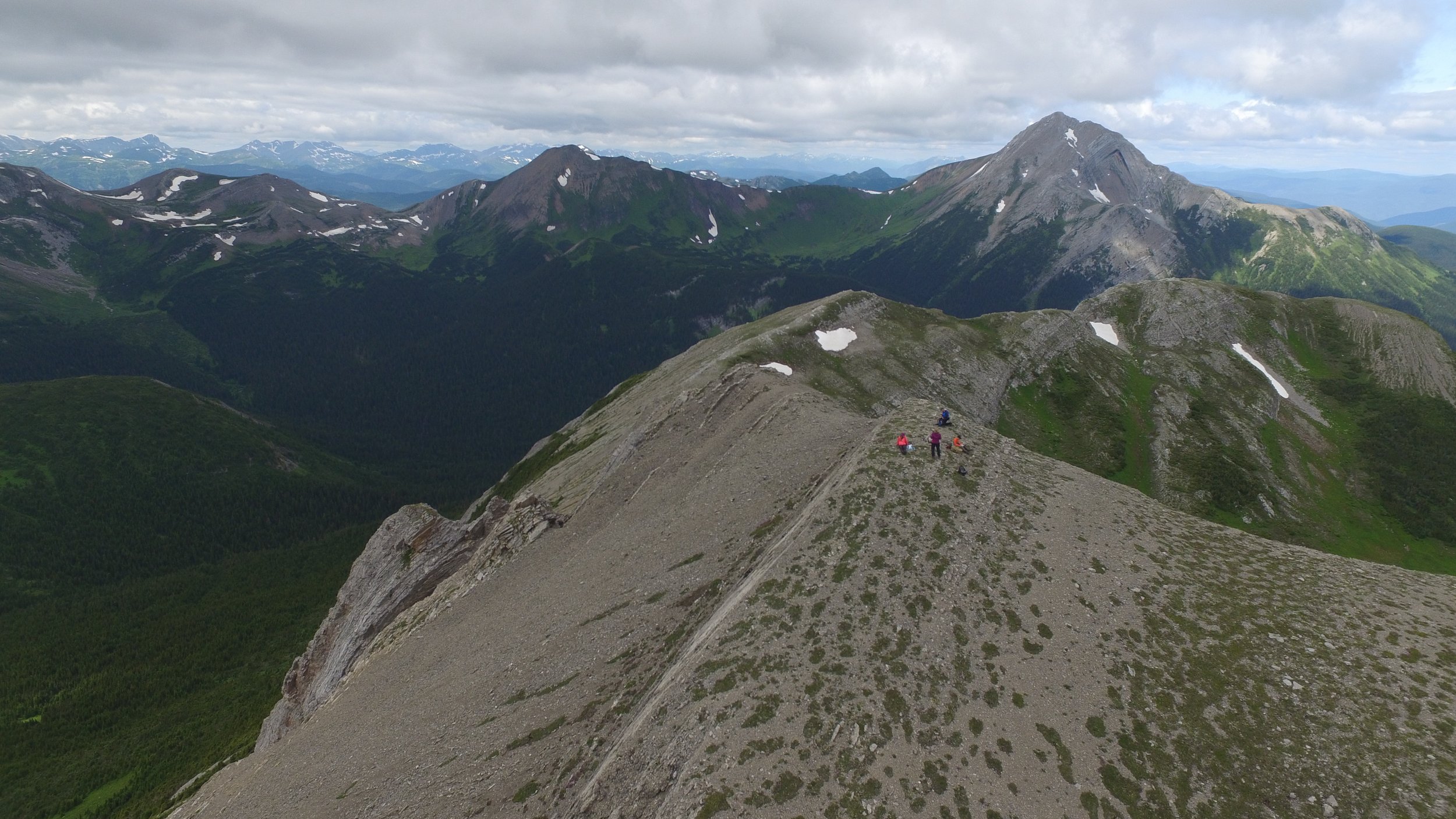
This spectacular and strenuous day hike climbs high into the alpine, following limestone ridges and culminating in an ascent of Pinnacle Peak (1912 m). The rewards for this hard work include breathtaking mountain views with intriguing geological features and fossils. The summit climb looks challenging from a distance but turns out to be a simple scramble. There are spectacular views of the Windfall Lake area, Sentinel Peak with a glacier on its eastern flank, and Mt Crum with its distinctive anticline.
Distance | Time:
7 km to peak and back | 4-6 hours
Elevation Gain: 690 m
Trail Rating:
Challenging

Features:
Spectacular route to alpine summit.
Caution:
Steep route, lots of elevation gain, alpine conditions.
Note: This is not a developed trail, but rather a route. It is only suitable for competent, experienced hikers with confident route finding skills.
-

Trails
Experience an awe-inspiring and exhilarating full-day trek that takes you through breathtaking alpine terrain. Traverse limestone ridges as you ascend to the magnificent summit of Pinnacle Peak, reaching a staggering elevation of 1912 meters. Prepare for an ascent of 690 meters, rewarded with panoramic vistas of the surrounding alpine peaks. Extend your adventure by embarking on a captivating ridgewalk to the south and west, immersing yourself in the stunning beauty of this untamed landscape. Download the WNMS Hiker’s Guide for more information.
-

Fossils
The limestone rocks at this location protect the fossils of creatures that lived in the sea long ago. You can find trilobites, brachiopods, crinoids, blastoids, ammonoids, clams, bryozoans, and many types of burrows made by small invertebrates. One interesting thing is that you can easily recognize the extinct corals, which come in two forms: solitary (rugose) and colonial (tabulate). As you get closer to the top of Pinnacle Peak, you'll come across a special rock layer that displays a lot of coral fossils.
-

Trip Link
For the return journey, it is recommended to follow the same route as the ascent. If the weather conditions are favorable, you have the option to extend your hike by heading south from the pinnacle of Pinnacle Peak towards an unnamed peak or a ridgetop to the west, or even venturing towards the beautiful Windfall Lake. These alternative paths offer challenging terrain and are suitable only for physically fit and well-prepared hikers. However, they reward you with unparalleled ridge-walking experiences and additional vistas of the mesmerizing peaks to the south and west.
-
Geology
The rocks you see along the way are from the Mississippian Period, which happened about 359 to 323 million years ago. In some places in the world, rocks from this time period have preserved the remains of ancient forests and have a lot of coal. But in the Tumbler Ridge area, the rocks from this time were formed differently. They were made from small pieces of dirt and sand that settled at the bottom of a warm and shallow sea.
-

Photography
Capture breathtaking photographs of the magnificent mountain vistas from the summit of Pinnacle Peak. The awe-inspiring views offer endless opportunities for stunning photography, showcasing the grandeur of surrounding mountain peaks.
-

Caution
This is not a developed trail, but rather a route. It is only suitable for strong, experienced hikers with good route-finding skills. The alpine ridges are often windy, and fog may roll in unexpectedly. Take a GPS, map and compass, and be prepared to use them. This route is in bear country; travel in groups and make noise. Please pack out what you packed in. Don’t wait until it’s too late, 911 rescues are free in BC
DIRECTIONS TO TRAILHEAD
From Tumbler Ridge, drive north towards Chetwynd on Hwy 29 for 25 km to the turnoff for the former Bullmoose Mine. Follow the Bullmoose Mine Rd for 17 km and turn left onto the Windfall Creek Forest Service Road. This signed turnoff is just before an electrical substation.
Follow the Windfall Creek FSR for 23 km. This road climbs over a pass at km 14 and goes by very scenic alpine areas. Turn left at km 23 and follow this side-road for 1.8 km until the parking area. The signed trailhead and outhouse is on the right.


thank you to our partners

experience tumbler ridge unfiltered. tag #tumblerridge to show us your adventures.