
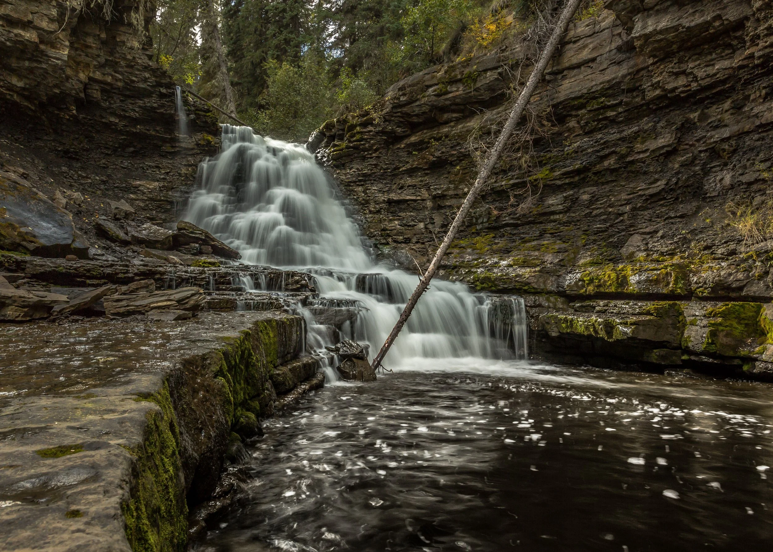
quality falls and quality canyon
As it makes its way to the Murray River, Quality Creek cascades down multiple waterfalls. The Quality Falls trail takes visitors on a short journey to the highest of these falls, where a picnic area and observation point await. Experience an interesting adventure near Tumbler Ridge by hiking the trail to Quality Canyon and Quality Mouth. This scenic trail takes you through mature spruce forest, with steep descents, leading to the picturesque confluence of Quality Creek with the Murray River.
Distance | Time:
Quality Falls: 2.5 km return | 1-2 hours
Quality Canyon: 7 km return | 3-4 hours
Elevation Gain:
Quality Canyon - 180 m
Trail Rating:
Quality Falls - Easy
Quality Canyon - Moderate


Features:
Picturesque waterfall.
Canyon, confluence of Quality Creek and Murray River.
-

Trails
The trail leading to Quality Falls has an easy rating and covers a round trip of 2.5 km.
The Quality Canyon trail is easy to navigate, with boardwalks over some wet areas in the first kilometer. At the 2.5 km mark, a signed fork marks the beginning of a triangular loop that follows Quality Creek on one side. You can hike the loop in either direction, but clockwise offers a more scenic although steeper route. Taking the left path at the fork leads downhill until reaching the Murray River level. The trail continues alongside the river before reaching the mouth of Quality Creek, a great spot for fishing and relaxation.
-

Snowshoeing
During the winter months, both Quality Falls and Quality Canyon trails can be traversed with snowshoes. However, exercise caution as both trails have some steep descents that can become slippery due to ice and snow.
-

History
Believed to have been constructed in the early twentieth century, the Quality Canyon trail holds historical significance as a pack trail that was used by pioneers like Bill Warn and John Terry to bypass the steep cliffs along the nearby Murray River. Ancient tree blazes are still visible along certain parts of the trail.
The rocks at Quality Falls are in the Kaskapau Formation and are about 95 million years old, from the early part of the Late Cretaceous Period. These rocks are overlain by sandstones and shales of successively younger ages.
-

Bird Watching
Besides common forest birds like the Hermit and Swainson's Thrush, Ruby- and Golden Crowned Kinglet, and Red Breasted Nuthatch, the Quality Falls trail features unique avian species. Listen and spot the winter wren near wet areas on the trail. The black-throated green warbler can be seen here at the western edge of its range. Spot the American Dipper flying along the creek at canyon level. The Pacific-slope Flycatcher can also be seen on the creek and canyon banks, although it is less noticeable.
-

Amenities
Quality Falls is outfitted with a picnic site and viewpoint at the falls. It is also a great spot to take a dip in the water on a warm summer day.
-

Caution
Exercise caution in the area below the falls as it may become slippery. Additionally, be mindful of sudden increases in water levels during summer rainstorms, which can result in flash floods.
Before the viewpoint into the canyon, a sign on a tree cautions hikers against descending during floods or high water. Braver hikers may use a rope to enter the canyon. Stay clear of the creek, particularly at the lower end where it rushes down the narrow canyon over the bottom falls. Be mindful of the risk of falling rock from above. Retrace your steps and use the rope to exit the canyon.
DIRECTIONS TO TRAILHEAD
Quality Falls: From Tumbler Ridge, take Hwy 52 (the Heritage Highway) north towards Dawson Creek. The signed parking lot is on the left, 6 km from the junction of Mackenzie Way and Hwy 52. The trailhead is at the back of the clearing. The winter parking for snowshoeing is the pullout on the right side of the highway, directly opposite the trailhead.
Quality Canyon: The trailhead is at the large roadside pullout known locally as Albert’s Point, 6 km from downtown Tumbler Ridge on Hwy 52 (the Heritage Highway). When approaching from Tumbler Ridge, use the second entrance to this pullout, as the first has poor visibility for approaching traffic. Below the pullout there is a large flat area. Follow the signs down through this area, along an ATV trail for a 50 metres, then into the forest (marked by another large sign).


thank you to our partners

experience tumbler ridge unfiltered. tag #tumblerridge to show us your adventures.


